
Much of the municipality is in the Sierra de Baza, within the natural park, where the Gor river originates. The Gor river flows from south to north through a deep and fertile canyon, excavated on the plateau between the basins of Guadix and Baza. At the bottom of this valley and on both sides of the river are ancient vegas arranged on terraces.
The land that now is occupied by the village has known human settlement from the Neanderthal man as evidenced by the numerous archaeological sites that have been exploited. There are remains that are ranging from the stage to the Muslim, through the Neolithic, Iberian, Roman and Byzantine Empire.
Points of Interest in Gor
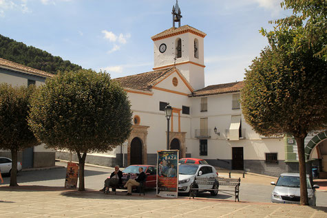
- Church: Iglesia de Nuestra Señora de la Anunciación;
- Spring: fuente de los siete caños;
- Castle ruins;
- Washing sinks;

Festivities in Gor
- San Blas is celebrated on the 3rd of February;
- Frome the 6th until the 10th of August are the festivities in honor of the patron San Cayetano held. These fiestas are noteworthybecause of its running of the bulls, held at eight o'clock on 8, 9 and 10, which already existed in the year 1622.;

Photo Gallery of Gor


Basic Information Gor
Gor (37°22′10″N 2°58′10″O)
Altitude: 1238 meters
Population: 797 inhabitants (2014)
Distances:
Distance to Granada: 74 km
Distance to the beach: 133 km (Almeria)
Distance to Airport Malaga: 208 km
Distance to Airport Granada: 89 km
Touristic level: low - medium - high
Authentic level: low - medium - high
Facilities:
- Supermarkets: yes
- Banks: yes
- Restaurants: yes
- Bars: yes